We return to the world building process. In the last segment we took a brief tangent to build out a capital city profile. This time we’re back for worldbuilding dominions for our map! Now, we won’t be creating every single sovereignty on the map today. We’re just looking at the largest dominions, those around one Atlas hex in size (152,295 sq miles or 394,440 sq km) and larger. To help put it in perspective, a single Atlas hex is larger than Germany, but smaller than France.
That’s all the introduction necessary I think, let’s jump into it.
Worldbuilding Dominions: Determining Size & Placement
When worldbuilding dominions the first question is where should they go, followed shortly by how large should they be? We will be using our dice to figure out the latter. For the former, we’re using our first three landmark types, the civilized landmarks, as our starting point. We pick a Capital City, Military Location, or Religious Site to start. Then we use our dice on the below table to determine the size (area) of the dominion.
Looking for more resources and references to help you run better games? I have pay-what-you-want content on DriveThruRPG to help you make your next session a little bit better. Download and if you like the content, throw me a few bucks. Every dollar helps to pay the bills and keep me motivated to create more content for you.
World Map Great Dominions Type & Size
Roll 1d6
- 6 Empire: 1d10+10 Hexes
- 4-5 Great Kingdom: 1d8+2 Hexes
- 1-3 Good Kingdom: 1d2 Hexes
Empire
A large collection of various lands and people ruled by a single, central authority. Subjects are ethnically diverse and often empires are carved up into provinces, which are ruled by a governor, with each essentially functioning as its own nation state but with obligations to the empire’s central authority. Sometimes governors are the former rulers of the land or they are foreigners appointed to the region by the central authority.
Great Kingdom
A normal feudal system with an extra layer where kingdoms and kings within the dominion owe allegiance to a great king, high king, or “king of kings.” Generally great kingdoms are successful because they share similar culture and ethnic ties. Sometimes these great kingdoms are built on conquest, but often they are an alliance or confederation and the great king may even be elected, similar to the Holy Roman Empire. We’re using the term Kingdom here but it could have a different form of governance or, you know, be ruled by a queen.
Good Kingdom

Similar to above, not quite great, but larger and more significant a dominion than most independent kingdoms, duchies, principalities, city-states, etc.
Rather than a king of king scenario, this kingdom may instead have duchies and principalities owing their fealty.
Worldbuilding Tips for Shaping Dominions
With the landmark location to use as your focal point and the number of hexes known, it’s time to assign the hexes. First, you can disregard world wonders and ruins when assigning your hexes. For BBEG monster lairs, mix it up. Sometimes put them inside a dominion, a constant problem the state is dealing with, and other times avoid them and shape your dominion around the BBEG’s sphere of influence. Good Kingdom sized dominions should never include another capital city, military location, or religious site in their domain.
Great Kingdoms can swallow one civilized landmark of a different type. By swallow, we mean fully encircle the location with dominion hexes. So a dominion centered on a mighty castle may also include a grand temple within its lands. And empires can swallow civilized landmarks of any type.
When it comes to empires and great kingdoms with 7+ hexes, try to completely surround your starting landmark location. It’s not always possible, but it is nice when the dominion’s central authority is well… central.
If you’re confused about where to expand you dominion here are a few ideas to help you decide.
- Expand towards and along the coast
- Follow hexes of the same biome type, nations tend to be wider East/West than they are tall North/South
What to Avoid When Worldbuilding Dominions
One of the big pitfalls to avoid when carving your map into dominions is making numeroud, large landlocked dominions. Through the course of history landlocked nations are pretty rare. Today, only 20% of the world’s countries are landlocked. Access to the coast is not only essential for pre-industrial trade, a coastline is also a major military defense and deterrent to invasion. History has shown amphibious invasions fail more often than they succeed.
Another pitfall to avoid is assigning a lot of coastal shallows to a dominion. Dominions are primarily land-based, just as countries on today’s maps focus on land boundaries and not what parts of the surrounding ocean are under their control. Try to limit water tiles in domains to coastal shallows only and only for dominions with a capital city, military location, or religious site situated on water tiles or the coast to serve as a primary port.
Let me know how you like the content and if you use any of my resources over on Twitter. It’s the best place to follow me or get in contact with me for questions, collaboration, or just to say hi!
Minimize including blocking terrain unless the domain can swallow it. These areas are often home to nomads and “hill people,” small, often intensely independent communities that want to live outside the control of a larger dominion.
- Ocean
- Mountain Ranges
- Dense Forests/Jungles
- Large Rivers
- Large Wetlands
- Deserts
Worldbuilding Dominions: Running Out of Hexes
Occasionally you may run into a situation where a dominion is assigned more hexes than you can allocate. Either you’ve run out of land to include or the hexes have already been assigned to a different dominion. The simplest way to deal with this is to just take what you can get and let the additional hexes drop unassigned and move on. Another tactic is to push the hexes out into the nearby coastal shallows where possible, even if the central landmark location for the dominion doesn’t provide access to the sea.
A more complicated, but fun experiment is to push into nearby, assigned hexes and note them as contested hexes. These are areas of land where the rulership is fuzzy with two or more dominions claiming ownership over the land and people’s within. Often this leads to a lot of chaos and flux about the laws of the land and how they’re applied, leading to a higher degree of lawlessness and commonplace border skirmishes between dominions. These areas are fertile ground for D&D adventures, especially low level adventures where players need to deal with mundane problems like livestock rustling and local bandit gangs.
For more ideas I suggest perusing the history of English/Scottish Border Reivers.
Atlas World Map Hexes Without Dominions
It’s unlikely that all the land of your world map is covered by dominions, that’s OK. Those areas that aren’t part of a larger dominion doesn’t necessarily mean they’re lawless wilderness. They may be wilderness, but they may also include dominions that are smaller than one Atlas hex.

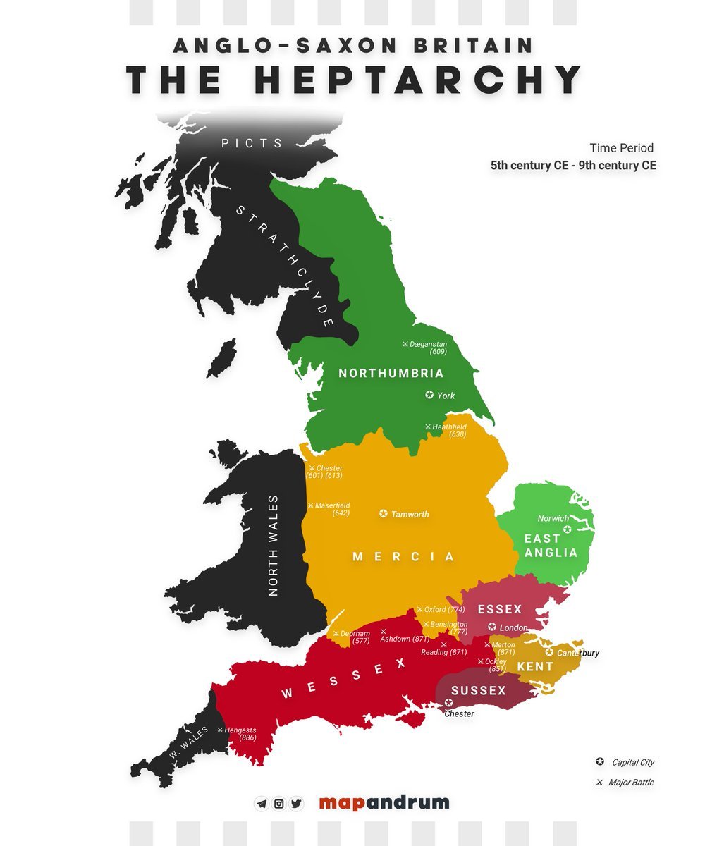
Remember, we’re only looking at BIG dominions. There will be plenty of smaller dominions. Great Britain is only slightly larger than half an Atlas hex and included the English kingdoms of Wessex, Sussex, Kent, Essex, East Anglia, Mercia, and Northumbria.
There will be plenty of opportunities to create dominions at a smaller scale of world building! And, that smaller size doesn’t necessarily mean they’re not worth exploring. It’s important to remember scale. For every world- or planar-spanning adventure you’re going to run dozens or scores of lower-level adventures and campaigns.
Like the content? You can help support me by helping to get this content in front of more eyeballs. Share this article on your favorite D&D subreddit, forum, and social media platform. Every little bit helps!
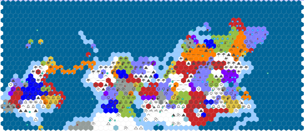
Here’s My World Map’s Dominions

Notes for Worldbuilding Dominions
With our big dominions mapped out we should add some notes about the dominions. The information we’ll include will be very similar to the information we put into detailing our capital city profiles. You can grab all that information, including the useful roll tables by following the link. I suggest opening it in another tab or window so you can quickly flip back and forth between them.
So here are some criteria we want to include for worldbuilding dominions at this point:
- Name
- Map Location
- Capital
- Demographics
- Major Religions
- Government & Current Leader
- Major Imports & Exports
- Age
- Notable History
These should give you a vague, but useful big picture idea of the largest dominions in our world. For the sake of being thorough I’ll go through each bullet with some more description.
Dominion Name
Names are important, but it’s often best to make this the last blank you fill in. Appropriate names are a lot easier to world build for your dominions with when you have some context for them. The capital city profiles post has good information about coming up with names that you may find useful if you struggle coming up with names!
Dominion Location
While it’s easy to remember where a dominion is when you’re building it but come back in a few weeks or months and without this information it will be impossible to tell one dominion from another. You can do this by simply stating something like, “located on the NE corner of the largest continent.” We need practical information at this time, not flowery words about it “spreading across the Plains of Dawn.”
Dominion Capital
Most of our dominions only feature on major landmark location so it’s pretty easy to tell what the capital is going to be. For dominions with multiple landmark locations, you may want to wait and choose the one that feels most appropriate with the rest of the information.
Worldbuilding Dominions: Demographics
After resource distribution on the world map, we dispersed our world’s ancestries across the map. Plugging in this information should be simple. Click here for a refresher on that post. So, using the same rolling feature we did for capital city profiles, we can come up with an overall demographic breakdown for the dominion. This doesn’t necessarily need to align with the demographics of a capital city profile. Maybe you’ll find out most of the dominion is dwarves, but they must live in the countryside and rural areas because the capital city is mostly humans.
Dominion Religions
Luckily, we took care of this a long time ago in the first section of this series. We already have our major religions outlined in our world building and assigned to continents. Really here we just want to know how popular those major religions are compared to local folk and spiritual practices.
Dominion Government & Leader
Pretty simple, at some point we’re going to need to know who’s in charge of our dominion and the structure of its government. You can choose it or roll on the 1d20 table from capital city profiles.
Dominion Imports & Exports
We still have our notes about distributed natural resources. Looking at what’s present and lacking in the dominion compared to its neighbors will make it easy to come up with a list of prominent imports and exports
Dominion Age

Deciding how old a dominion is will tell us a lot about its culture, power, and how recognizable it is in the world. We think of something like the Roman Empire being ancient, but even it was the new kid on the block at one point, struggling to consolidate its power and grow. A much different story compared to being so big it split itself in half and then one half collapsed. Is it fledgling, growing, reaching homeostasis “Golden Age?”, in decline, or on the verge of collapse?
World Build Notable History for Dominions
How did the dominion get to where it is today? Part of worldbuilding dominions means having a handful of notable historical events and defining moments commensurate with the dominion’s age will help ground it in the world. Again, it’s better to be vague at this point rather than too specific. Our players won’t care that the empire was defeated at a battle two centuries ago and built a defensive wall at the location. That’s unless they’re at the crumbling remains of the wall and using it as a landmark for the current adventure.
For an example of how many notable events to include in the history I would suggest following the “This is My Life” guidelines in Xanathar’s Guide to Everything and cross-referencing it with the 1d20 Current Events & History table from Capital City Profiles.
If you’re the type of Dungeon Master who uses an online management tool, here are some other linkable assets you may want to create at this time. If you’ve never used an online management tool for your D&D campaign, PhD20 has a nice overview of the most popular options that can help you decide if it would be a useful resource for your DMing.
- Landmark Locations
- Major Holdings & Settlements
- Influential Factions & NPCs
- Notable Geographic Features
- International Relations
- Cultural Touchstones
Again, these will primarily be empty categories for the moment. We want to avoid getting too far into the weeds at this point. Pretty soon we will be transferring our world building efforts from the highest level, the Atlas Hex, to the second level: the Region Hex. As much as I love top-level, macro world building I am very excited for us to dive into the finer details and share some of the techniques I’ve been using for years for my games.
Buy me a Ko-Fi and support the blog for as little as $1. Each dollar goes to keeping the ad-free website up and helps me purchase new resources to craft you fresh new content.
Worldduilding Dominions Example
Below is an example of one of my Good Kingdom results, Eastar.
| Dominion Name | Eastar (Thearain [Th-Weer-In] Réaltair) |
| Map Location | Atlas Hexes: X 41-42, Y 24 |
| Dominion Capital | Starfall Temple (Temple of Réaltair Tuiml) |
| Demographics | 30% Elves 30% Half-Elves 20% Gnomes 10% Dwarves 10% Other |
| Major Religions | 52% Pantheon One 25% Local Folk Practices 23% Pantheon Two |
| Government & Current Leader | Ruled by a religious council seated at Starfall Temple |
| Major Imports & Exports | Imports: Beer, Coffee, Poppy, Tea Exports: Fava Beans, Silk, Yams |
| Age | Stable, established for hundreds of years |
| Notable History | – Founded after the Starfall event, the impact deeply wounded the existing communities and caused an unnatural plague – Starfall Temple was built in the aftermath to aid, observe, and oversee the impact area and became the central authority of the area – Enjoyed an 8-year mini heat wave that improved crop yields and allowed the area to prosper – Suffered the wrath of Djinni slavers – A volcanic eruption happened |
Major Dominions & Next Time on Worldbuilding Process
That’s all for this session of the Worldbuilding Process. If you’ve followed along, you should have some great notes on the largest political players in your setting.
I think in the next installment of the Worldbuilding Process we’ll discuss Heartlands, Marches, and Wilds and maybe start our dive into the Region Hex magnification. Interesting stuff for sure. Thanks for reading, I appreciate it and I hope you were able to find something useful for your world building and game mastering.

Pingback: An Introduction to D&D Region Hex Mapping - Red Ragged Fiend
Pingback: D&D Hex Map Region Scale Example World Building - RRF